These are parts of Downton that were outside the scope of the Downton Trail when it was first published. To see
them click on the title and click again to hide the text.
In about 1695 Charles Duncombe, an MP for Downton, had a new country home built on The Barford Park Estate. The house
was destroyed by fire in 1815, at which time it was the residence of the Stockman family. The trees leading from
Barford Park Farm to the lane are all that remain. The Duncombe family’s connection with the Downton area survives
until the present day as The Earl of Radnor is descended from a Duncombe line.
One of Downton‘s most popular legends involves Barford Park. It is said that at the age of about six weeks Queen
Elizabeth 1 was taken by her nurse to stay at the house. Unfortunately the child died shortly after her arrival and
the nurse, fearing for her own safety, rushed in to the village and stole the first baby she saw. However, in her
anxiety to save her head from the block she picked up a baby boy by mistake.
When the house was pulled down after the fire of 1815, the old cellar yielded a small coffin containing the bones of
a very small child. So, Queen Elizabeth l was in fact a Downton Boy and this explains why she never married, as well
as her tremendous power of leadership and her love of The village.
This legend is remarkably similar to that of "The Bisley Boy" which has it that the young
Elizabeth at age 11 was sent to Bisley in Gloucestershire. She died and a boy was used to replace her as he was the only
one of the right age with red hair. Which version is the true one is open to debate, but naturally we think the Downton
version is the true one!
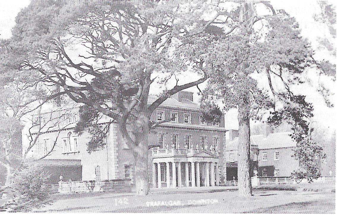
Trafalgar House (pictured below circa 1910)is a fine grade 1 listed country house, which can be glimpsed through
woods from various points along footpaths off Barford Lane and in the wider area.
Most of the land and buildings in this area once formed part of The Trafalgar Estate. The house was previously
known as Standlynch - which lives on in the name of the locality - and was built on the site of an older property
in 1733.The estate was purchased by the Government in 1814 and given to the heirs of Admiral Nelson, in gratitude
for his services to the nation. It was at this point that the name of the house was changed.
The now closed Standlynch Chapel can be accessed via a footpath leading off Barford Lane via Standlynch Mill and
hence across meadows towards Charlton-All-Saints. A church on this site, dedicated To St. Mary, is thought to have
been founded in 1147 as a daughter church to St Laurence‘s in Downton. Although part of the late medieval chancel
survives, the church was substantially rebuilt in 1677 by Maurice Dockland - the then Lord of Standlynch Manor -
for use as a private chapel.
The chapel was restored in 1846 by Horatio, 3rd Earl Nelson and services were conducted by his private chaplain.
The residents of Charlton and Standlynch were allowed to worship here until the Church of All Saints was built in
Lower Road in Charlton in 1851.
Between 1859 and 1866 the chapel was restored and rebuilt in the early Gothic style by William Butterfield. In 1914
Thomas, 4th Earl Nelson, converted to the Roman Catholic faith and used the building as a private chapel, served by
a resident priest. The chapel was rededicated to Mary Queen of Heaven and St Michael and All Angels. The chapel has
been closed since 1947, when The Nelson family sold the Trafalgar estate.
The chapel is well worth a visit, especially in the early spring for a wonderful display of
snow-drops, daffodils and bluebells.
The former Rehoboth Chapel on Lode Hill is now used as a private garage. In the early 1840s a group of Strict
Baptists were formed by an orator called Mr Tiptaft, locally known as ‘The Thunderer’ and the chapel was founded
in 1845. When a later pastor died in 1858 there was no successor and the congregation gradually dwindled. The chapel
had closed by the 1950s and by 1975 had been converted to its current use. The house the garage serves is on the
site of the former dwelling of the chantry priest, and was once known as Burnhill's Chantry.
The large building of the junction of Lode Hill with Slab Lane was originally built in 1814 as a Wesleyan Methodist
Chapel. In 1849 some of the members differed on points of doctrine and broke away to form The New Wesleyan Reformed
Chapel (see Plaque 14). The building was then used until the 1870s as the Downton Cottage Hospital. It has now been
converted into flats. The most recent use of the building prior to this was as Refell's butcher's shop, the name of
which can still be seen painted on the gable of the building facing Lode Hill.
Although now overgrown, steep banks either side of Lode Hill show where a railway bridge, known as ‘The Arch’,
stood before it's demolition in 1968. A cottage formerly stood in the section of garden of the property immediately
to the east of the arch, but was destroyed by a fire, said to have been caused by a spark from a passing train.
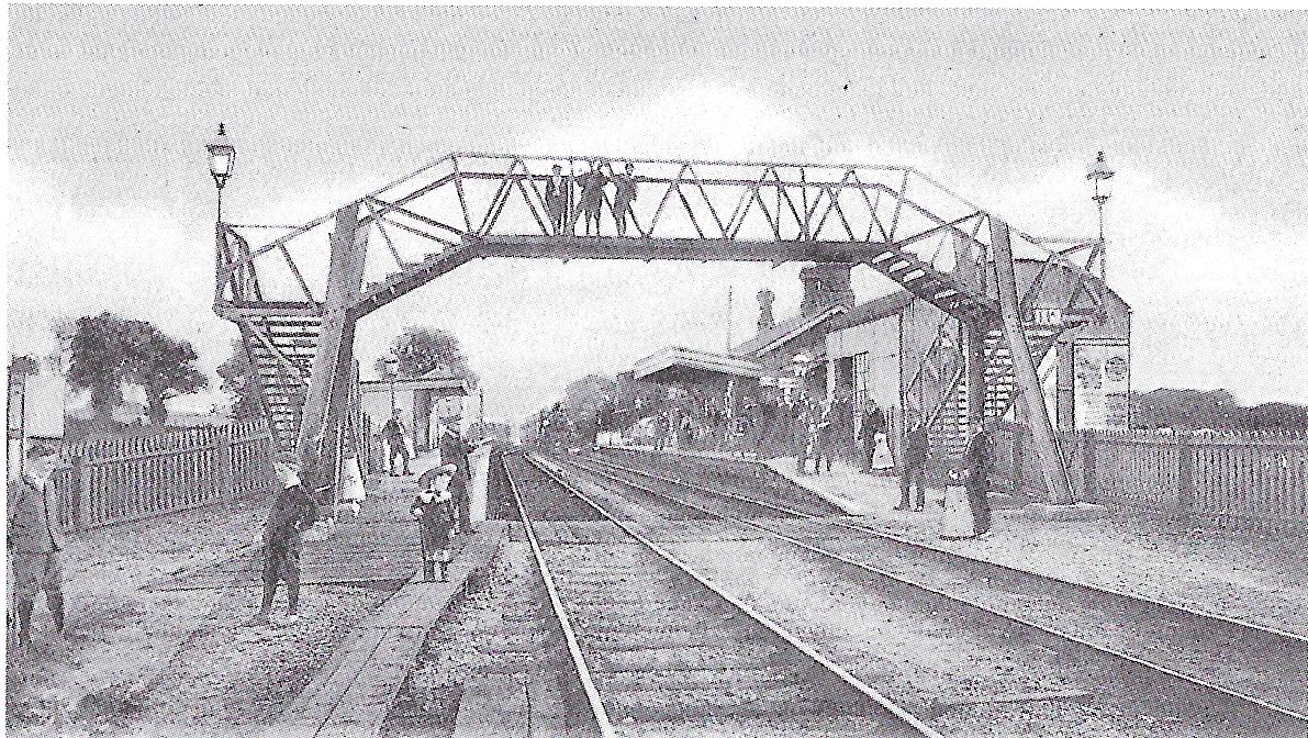
Downton Railway Station is pictured below circa 1910. The Station, off the northern side of Lode Hill, was opened by
Countess Nelson for The Salisbury and Dorset Junction Railway on 20 December 1866, and closed almost 100 years
later whilst under the control of British Railways (Southern Region).
The last trains ran on 4 May 1964, when 100 school children travelled to Breamore and back. The last ticket was
purchased from stationmaster Harry Hepper by Sue Grice. The station was subsequently demolished and the Sidings
development was built on the site during the late 1970s and early 1980s.
A footpath runs north from The Sidings towards Standlynch and Alderbury. The route of the old railway line can be
seen running close to this path for the majority of its length, together with associated fencing and bridges.
Around half a mile along the footpath the surface of a field completely hides an old tunnel, now filled with chalk
and rubble. Legend had it that the tunnel was haunted by the ghost of a carter who, having lost control of his horse,
plummeted down the embankment and was hit by an emerging train.
However, there seems to be no official record of this incident and it is suspected that this was a tale put about
by older boys after the railway closed, in order to keep annoying youngsters away from their playground.
For more details of the station,
this book is a good reference. (Note that it's quite a large file, so may be slow in downloading!)
For a video of a couple walking the line from Verwood to Alderbury, click here.
For a simulator video of a trip from Fordingbridge to Salisbury, click here.
For the Wikipedia article on the Salisbury and Dorset Junction Railway, click here.
Accessed from Moot Gardens, off the eastern side of Moot Lane, the Downton Millennium Green is maintained as
recreational space for the enjoyment of villagers and visitors alike.
This amenity was made possible as result of a grant from the Millennium Commission, through the Countryside
Commission, a generous donation from Downton Parish Council and additional locally-raised funding. The area
is typical of a river valley running through chalk downlands and provides a wealth of wildlife habitat associated
with a water meadow environment.
At the southern end of the green, a track alongside the river leads to the railway embankment with the Pile Bridge footings
still in place. Turning left the railway track bed is still in reasonable condition for a walk which comes out at
the sewage works on Moot Lane.
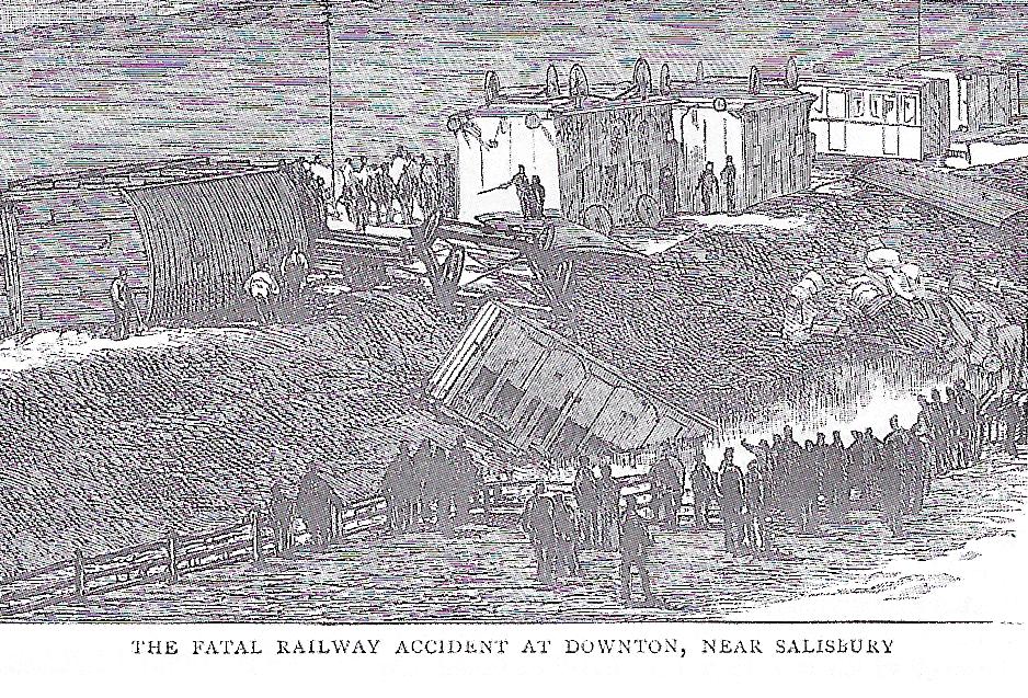
Just beyond the southern end of the now built-up part of Moot Lane, Pile Bridge carried the old railway line across
the River Avon.
On Tuesday 3 June 1884, the 4.50pm train from Downton had just crossed the bridge when its middle carriage left the
rails. Seven carriages crashed into the adjacent meadow and three were smashed to pieces - two of them having fallen
into the river. Downton Agricultural College (see below) used the fields and meadows around the bridge and staff
and students were fortunately on hand to assist the injured.
In recognition of their acts the South West Railway Company awarded a cup to the Principal and students of the college
as a mark of appreciation for their assistance. The specially made cup was known as The Wrightson Cup after the President and Principal
of the college, Professor Wrightson. In 2005 the Downton Society donated the Wrightson Cup to the Trafalgar School for Downton
(see below), and it is now presented annually to a pupil that has demonstrated a particular brand of courage.
Thirty people were injured and five were killed in the accident, including the daughter of the station master at
Fordingbridge. The incident is known as The Downton Rail Crash but it actually happened in the parish of North
Charford (now part of Breamore).
Even further south along Moot Lane is the site of the old Downton Brickyard. Although actually located just
within the parish of Redlynch, the ‘Downton‘ brick was manufactured here. This was the last of several brickyards
in the Downton and Redlynch area. It was opened by Chas. Mitchell & Sons Ltd (whose offices were at the company’s
sawmills in Lode Hill) in about 1935, and closed in 1991. Although it was reopened in l998 by the New Forest Brick
Company, the yard was forced to close again in March 2000.The Forest Edge residential development has now been built
on the site.
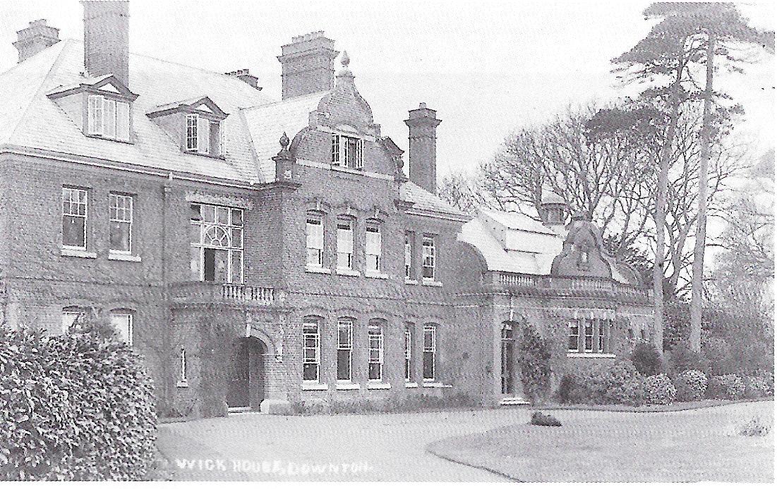
The former Wick House is sited off the end of Mesh Pond, off Wick Lane. Many of the older properties in the locality
- including Wick Lodge, at the junction of Breamore Rood with Barnaby Close - were formerly part of the Wick Estate,
and a large area of its associated open land has been developed for housing.
Wick House itself was an imposing Victorian country residence constructed in 1890. It has now been divided into three
properties and its adjoining outbuildings converted into dwellings. The picture below dates from circa 1910.
In 1921 Emily Bonvolot of Wick House purchased land for Memorial Gardens for the village, in memory of her son Edward
(see Plaque 3). During World War Two troops were billeted in the billiard room of the house. In the 1950s Mrs Russell
Grenfell opened the Wick House Girls Preparatory School, comprising three classrooms and six dormitories catering for
35 pupils. The grounds included a playing field, hard tennis court, two netball pitches, an archery range and a
riding field.
Heading south on the A338 road towards Breamore, Trafalgar School for Downton is located on the edge of the main
village. The school was opened in 1965 as Downton Secondary Modern School (known affectionately to ex-pupils as
"The Academy”). In the early 1970s the school become comprehensive and changed it's name to Downton School. The
school was renamed again in October 2005 to commemorate the 200th anniversary of the Battle of Trafalgar and its
local association with the Trafalgar Estate (see above).
The main building of The Downton College of Agriculture was sited some way over the Hampshire border at North
Charford Manor House, but fields in Downton Parish were used for practical purposes and the college employed many
villagers between its opening in 1880 and closure in 1906.
The President and Principal of the college, Professor John Wrightson, was an acknowledged expert on agricultural
practices and was the author of the Downton Series of text books, published by Chassell & Company during The 1890s.
In the late 1600s and early 1700s a canal was built to allow barges to go from Christchurch harbour to Salisbury. It passed through Downton, some
traces are still visible near Newcourt Farm, and it's thought that the canal passed under The Borough at Mould's bridge. However as a trade route, it
was not very successful as a lot of the works were damaged in a storm and the Avon valley was not really suitable ground.
For a detailed story of the development of the Downton Canal, click here.
For the Wikipedia article on the River Avon, click here.
And for a lighter look at the canal, try clicking here.
In the 17th Century, it was realised that the productivity of low-lying farmland could be significantly improved by manually flooding the grassland -
under strict control! This was achieved by digging channels for the water and associated hatches, gates etc to control the water. The land along the
Avon was particularly well-suited for this - a good introduction is the website produced by the Harnham Water Meadow Trust (click
here).
For a more detailed story of the development of the Downton water-meadows, click here
Currently under construction!
In days gone by, there was considerable industry in Downton - energy was produced by water mills at the Tannery Bridge, gas for lighting was
produced in Green Lane, and electricity was generated by hydro power at the Tannery Bridge. Several blacksmiths shod horses and mended agricultural
equipment, and latterly Downton was world-renowned as for Downton Engineering which produced tuning kits for Minis.
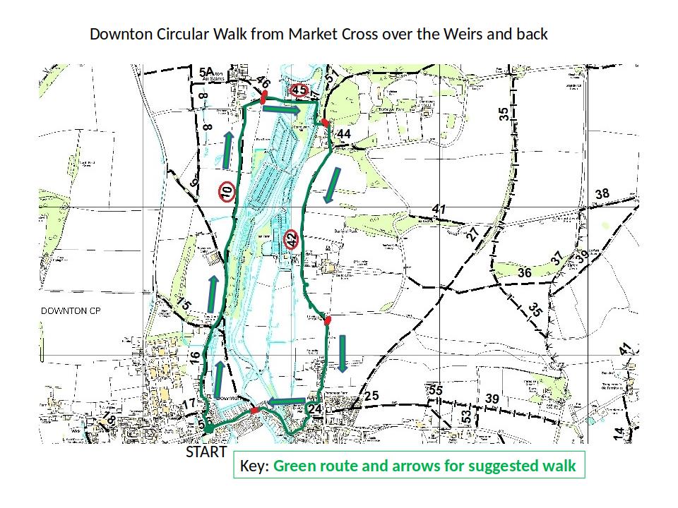
The Downton Circular Walk was formally opened in November 2020. It's about 1½ to 2 hours and is on footpaths all the way - it’s a bit muddy
in parts at the moment, but should be fully accessible to all.
From the Borough Cross past the Trafalgar Fisheries river crossings and return.
Walk difficulty: Easy (maybe muddy in the winter)
Approx 1 1/2 to 2 miles
Start Grid Ref: SU 17510 21516
Post code SP5 3LY
Public transport to start; use the X3 from/to Salisbury/Bournemouth, alight at the Bull Hotel stop and then from the west side of the A338 catch
the No 44 into the village and get off by the Goat Inn (can be walked in about 5 mins)
Starting point: Start at the Borough Cross outside the Co-op on the Borough
Finish after walking back down the Borough road to the Borough Café and the Goat Inn.
Cars can be parked to the rear of the Co-op and the start is from the Borough Cross in front of The Goat Inn. Looking north,
cross the road via the zebra crossing ahead and then head up Gravel Close to a farm gate with ‘Private Road’ sign.<
You will see a finger sign: "Circular Walk" Allow 11⁄2 - 2 hours.
Route Instructions
Location Comments
Pass through the side gate past a dog poo box and carry on to the gravel track then jinx right and left onto a concrete road still heading
north. The New Court Cut (river) is on your right side.
The remains of an ancient Tithe Barn at New Court Farm and an ‘H’ shaped old farm house which you can see to your left.
Follow the concrete path until a farm gate across the road near some barns and cattle sheds, and use the kissing gate to your right into
the field and continue north across the field to a small bridge over the ditch
and kissing gate marked with a way mark. Now cross the next field to a similar gate, and over the next field to the top left hand corner next to
some houses, this is the edge of Charlton All Saints.
Admire the beautiful water meadows and the tranquillity of the carrier, spot heron over the trout farm on your right.
The river is particularly beautiful here, as are the trees. Bird spotting recommended.
Leave the field through a kissing gate, cross the farm track to another kissing gate on the other side, and then follow
the worn track slightly right towards the river bridges.
At the wooden stile on the second bridge please note the dedication to Dawn Halski, who loved this walk, and the
special dog gate passage to the left.
Now after crossing the river, follow the rather muddy path through reeds and undergrowth to a bridge by the weirs
and deep pool. Turn right and work your way between the rivers right and left over the river level management sluices. This section is
very dramatic it is well worth stopping for a little sustenance after the next bridge before turning left in front of the old
mill house and barns.
You will then be facing an old mill, bear left up the hill.
Make your way up the gravel track keeping the garden wall on your right.
On your left is Trafalgar House woods; you could take a short excursion to a lovely viewpoint of Trafalgar House.
Fork right past the family chapel on your left. Still keeping the high garden wall on your right take the path to a
kissing gate into the field. Join the gravel farm track heading south towards the farm buildings in the distance.
Look at the old Nelson family graves and admire the spookiness of the chapel! Full of snowdrops in the spring and other beautiful wild flowers.
Please note the lovely old oak and ash trees in the park land either side there are usually some horses to say hello to. There are also
occasionally some cattle - be careful if you have dogs with you.
Now pass through the farm gate leaving it as you find it, usually closed. The fish farm buildings are on your right. This track takes you to
Barford Lane, bear right and keep well tucked in on the right of the road. After 600 metres you will pass the Catholic Church and then you
are back into the village.
Enjoy the views of the water meadows and the Church from the village.
Just before the renovated ‘Old School’ buildings, turn right down Snail Creep to the St Laurence Lychgate. Turning
left down Church Lane you will find a fish and chip shop ahead, across the High Street, and on your right is the
pharmacy. Stay on this side of the road now heading West on the pavements.
The old school buildings have been converted into 3 house units alongside the original caretaker’s house.
The pavement then takes you over the River Avon (Mill Race) which originally fed a number of water mills to your
left and then the lovely stone bridge known locally as the iron bridge due to its wrought and cast iron railings.
You might notice that some of the houses have two numbers over their doors. That is because some of the early ‘Rotten Borough’
numbers are still shown from the days when Downton had two Members of Parliament!
You are now on the final part of this walk as you make your way to the Borough Cross with the Borough Green on your left.
We hope you have enjoyed our short circular walk through parts of the village and countryside around.
Do please visit the Borough Café and or the White Horse Inn after your walk.